The 'Lost Lakes' map enables users to track real-time changes in Arctic lakes, shedding light on the crucial role of permafrost in climate change.
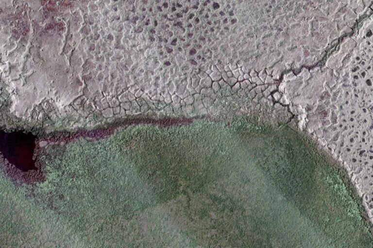
The Arctic is home to millions of lakes situated atop perpetually frozen soil known as permafrost, which plays a vital role for local wildlife and human communities. As climate change accelerates warming, permafrost is beginning to thaw, leading to the formation of new lakes and the disappearance of existing ones. To monitor these critical changes, researchers have developed the interactive map named "Lost Lakes," encompassing approximately 4 million lakes across the region. Users can observe variations in these lakes in near real-time, as well as track alterations since 2016.
The Role of Permafrost in the Arctic Ecosystem
Permafrost isn’t just a layer of frozen ground; it serves as a crucial component of the Arctic ecosystem. For many plant and animal species, the presence of permafrost creates a stable environment. In turn, this stability supports local biodiversity, allowing ecosystems to thrive in conditions that would otherwise be inhospitable. However, as climate shifts begin to alter these temperature patterns, we’re entering uncharted territory. The ramifications of a thawing Arctic are profound and multifaceted.
These changes affect not only local wildlife but also indigenous human communities who have depended on the ecological balance that permafrost helps maintain. When lakes form and disappear, the resulting landscape shifts can disrupt traditional hunting and fishing practices, which are vital for subsistence in these areas. Furthermore, the impact of changing water levels could affect migratory patterns and breeding grounds, threatening species critical to local cultures.
Introducing the 'Lost Lakes' Map
The "Lost Lakes" interactive map is a significant step toward transparency in understanding these ecological changes. Researchers have made it accessible to both scientists and the general public, allowing a wider audience to engage with climate data. This dual accessibility could empower individuals concerned about climate change and encourage grassroots movements advocating for environmental preservation.
By mapping about 4 million lakes, "Lost Lakes" offers a detailed view of how rapidly the Arctic is transforming. Users can see not only current water levels and lake formations but also historical data that provides context for understanding these shifts. That sense of continuity makes the findings more impactful. It illustrates not just the damage currently manifesting but also the timeline of change—how long these lakes have existed and how quickly conditions are altering.
The Implications of Thawing Permafrost
As Ingmar Nitze, a remote sensing researcher from the Alfred Wegener Institute, points out, the ramifications of thawing permafrost extend far beyond local ecosystems. Much of the Arctic ground is underpinned by ice-rich permafrost that has sequestered vast quantities of carbon over millennia, effectively locking away decomposed plant, animal, and microbial matter within its icy embrace. The thawing of this permafrost unlocks that carbon, releasing greenhouse gases like carbon dioxide and methane into the atmosphere, which could further accelerate global warming.
This situation is critical. We're witnessing a feedback loop where warming leads to thawing, which releases carbon, contributing to even more warming. Monitoring through tools like the Lost Lakes map plays a vital role in understanding the global implications of these localized changes. Climate scientists can establish models to predict future shifts, allowing for better preparation and mitigation strategies.
Significance of the 'Lost Lakes' Initiative
The significance of the "Lost Lakes" mapping effort lies in its ability to transform raw data into a digestible format for varied audiences. Scientific jargon can often alienate the public, creating barriers to understanding climate issues. By designing a user-friendly tool, researchers allow anyone to grasp the urgency of climate change, especially as it relates to permafrost and its broader impacts.
Not only that, but tools like this can inform policymakers, prompting discussions around sustainable practices and climate action. If you're working in this space, whether it’s research, policy, or activism, the information provided by the Lost Lakes initiative can be integral to your efforts. The more people who understand these challenges, the more likely they are to advocate for change.
Future Outlook: Navigating Uncertainty
The future of the Arctic, hung precariously between ecological transformation and climate preservation, is uncertain. As permafrost continues to thaw, the flow of information about these changes will be critical. The 'Lost Lakes' map is just one representation of broader climatic shifts that are occurring. Experts will need to stay vigilant, using it as a tool to identify trends and respond accordingly.
That said, this interactive map is merely the beginning. As technology advances, we can expect even more sophisticated methods of monitoring our changing environments. Remote sensing technologies and satellite imagery can provide increasingly detailed insights, making it possible to predict patterns before they manifest. (And this is the part most people overlook.) Just as crucial is the role of community engagement; a well-informed public can drive action, cultivating a collective response to what is undoubtedly one of the most pressing issues of our time.
Discussion
Sign in to join the discussion.