Coastal erosion is reshaping Ayetoro, Nigeria, where community volunteers and the Nigerian Conservation Foundation monitor migratory waterbirds.
A coastline in motion
At Ayetoro, in southwestern Nigeria, coastal erosion is taking land and the wetland habitat used by migratory waterbirds. From 2010 to 2020, erosion advanced by an average of more than 10 meters a year. That average gives a sense of the pace, but it doesn't mean the shoreline moved evenly in every place or in every year. Submerged buildings now mark the shifting boundary between land and sea, turning a gradual environmental process into a visible record of what has been lost.
Erosion changes more than the line on a map. Wetlands can provide feeding and resting areas for birds, and a retreating coast can alter the amount, shape and condition of that habitat. The source account doesn't specify how much wetland has disappeared, or which particular areas are most affected. Still, the combination of a rapidly advancing shoreline and buildings already underwater points to a place where habitat conditions are changing within a relatively short period.
Coastal boundaries aren't fixed. Waves, tides, sediment movement and local geography all shape shorelines, while erosion can vary from one stretch of coast to another. For people monitoring wildlife, that variability matters: a bird count records what is present at a particular place and time, while the condition of the habitat around it may be shifting. A count can show changes in bird use, but it can't by itself explain whether those changes stem from erosion, other environmental pressures or ordinary variation in migration.
A stopover along a migration route
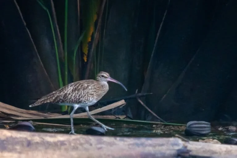
The wetland remains a stopover and wintering site for Eurasian curlews, whimbrels and common sandpipers. The birds arrive between October and January as part of annual migrations between northern breeding grounds and warmer wintering areas. That seasonal pattern makes Ayetoro part of a much wider ecological system: the birds' use of this wetland is connected to conditions at other points along their route.
Migratory birds depend on a sequence of places where they can pause, feed and rest. If one site changes, the effects may be difficult to interpret in isolation. A lower count could reflect a shift in local habitat, changes elsewhere on the route, or the timing of a survey. This is why repeated observation matters. A single visit offers a snapshot; monitoring across seasons and years can help establish whether patterns are changing.
The species named here also make clear why counts need to be attentive to identification. Different birds may use the same wetland, but they can differ in appearance and behavior. Recording which species are present, and how they use a site, gives conservation groups more useful information than a general tally of waterbirds. Photographs and behavioral observations can help preserve context around those counts.
Local volunteers track the birds
Community bird groups help the Nigerian Conservation Foundation (NCF) monitor the wetland. Volunteers receive stipends to identify and count birds, record population data, and gather behavioral observations and photographs. They also take part in an annual count at the start of each year. The work combines repeated field observation with local knowledge of the site, giving monitoring efforts a presence beyond occasional visits by outside researchers.
Counting wildlife sounds straightforward, but reliable monitoring depends on consistency. Observers need to recognize species, record what they see in a comparable way and note the conditions surrounding an observation. A photograph can support an identification later; behavioral notes can show whether birds are feeding, resting or moving through. None of these records settles every question about a population, but together they give conservation staff a stronger basis for understanding how birds use a wetland.
Stipends also recognize that monitoring takes time and effort. Volunteers must be able to reach observation areas, spend time watching birds and record findings carefully. The account doesn't describe the amount of training or the frequency of surveys, so the exact reach of the work isn't clear. Even so, involving community groups can help maintain continuity in places where habitat and wildlife need to be watched over time.
Here's the thing: a bird count is also a form of habitat documentation. When volunteers return to the same wetland and record what they find, their observations can help establish which species are using it and when. For Ayetoro, that work takes on added meaning because the coastline itself is changing. (And this is the part most people overlook.) The value of a count isn't only the number of birds; it's also the record of where they were found as the shore shifted.
Monitoring across countries
The monitoring work extends to two other sites in Nigeria. It's part of the Climate-Resilient East Atlantic Flyway project, funded by Germany’s International Climate Initiative. The project aims to strengthen monitoring and management of migratory waterbird habitat in 11 countries along Africa’s Atlantic coast. That wider scope reflects the basic geography of migration: birds cross national borders, while conservation work is often organized site by site and country by country.
Coordinated monitoring can make observations from different locations easier to compare, provided that surveys use compatible methods. It can also help conservation groups see how individual wetlands fit into a larger network of stopover and wintering sites. A project covering several countries doesn't automatically mean every site faces the same pressures or needs the same response. Erosion at Ayetoro is a local condition; the broader program provides a framework for gathering information across a larger region.
Climate resilience in this context centers on whether monitoring and habitat management can respond to changing conditions. The project description establishes an aim, not a reported outcome: it doesn't say how much habitat has been protected, whether bird populations have changed, or what specific management measures have been adopted. Those distinctions matter. A funding program can support the systems needed to understand a problem, but measuring progress requires evidence gathered over time.
What the record can show
For Ayetoro, tracking the birds also documents what the advancing coastline is doing to their habitat. That link gives local observations a purpose beyond species inventories. If the shoreline continues to shift, records made at the wetland may help show whether the birds continue to use the site and how their patterns change. The evidence will be most useful when counts are repeated and interpreted alongside observations of habitat conditions.
There are limits to what monitoring can establish. Bird counts can describe presence and abundance during surveys, but they don't on their own identify the cause of a change or predict what will happen next. Shoreline observations, photographs and habitat records can add context, while longer runs of consistent data can help distinguish a durable pattern from a short-term fluctuation. No single method answers every question. A record in motion.
This is more significant than it looks. Ayetoro's submerged buildings make coastal change visible, while the volunteers' records offer a way to track what that change may mean for wildlife. If you're working in this space, the practical lesson is that habitat monitoring and species monitoring belong in the same conversation. One measures the changing place; the other records how migratory birds use it.
And yet, data alone can't hold a shoreline in place. Its value is that it can make change legible to the people responsible for understanding and managing habitat. Whether the monitoring will reveal a long-term shift in bird use remains an open question; the information described so far establishes a way to keep watching.
Mongabay originally published this article. Mongabay.

Discussion
Sign in to join the discussion.